Post by LOU on Jul 28th, 2023 at 2:59pm
INS vs IRS
Not long after the end of WW-2 engineers at MIT started working on a new type of navigation system called Inertial Navigation System.
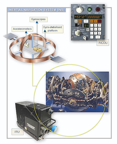
The older INS used sensitive accelerometers and real, spinning mechanical gyroscopes to stabilize a platform that rotates independently to the INS. So, as the inertial navigation system rotates, the stabilized platform inside it does not. In this way, the system learns about its orientation and can make use of the measurements from the accelerometers. The downsides of this type of system are gimbal lock and the high cost and complexity. Later came the strap-down system which as it’s called – is strapped down to the aircraft and does not have the gyro stabilized system.
To capture the measurements needed for navigating in 3D space, the axes of the inertial sensors are laid out in a mutually perpendicular way. In other words, each axis is at 90° to the other two axis. These systems provide data on linear and angular acceleration, linear and angular velocity, position, attitude (roll, pitch), platform azimuth, magnetic and true heading, altitude, body angular rates and more. Early on, airlines decided not to depend on just GPS since they are run by the military and could be jammed or otherwise messed with. The inertial system is self-contained to avoid outside interference, but GPS and other radio nav systems can be used to make sure of the accuracy.
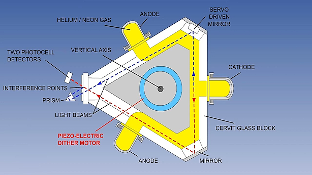
The main difference in the IRS system is that instead of mechanical gyroscopes, ring laser gyro systems are used where there is no moving mass. Instead, laser lights go around circular paths to sense the acceleration in different planes. An exception in terminology is that on the Boeing 777/787, the IRS is called the ADIRU system – standing for Attitude Direction Inertial Reference Unit.
The IRS system can take from 5-20 minutes to align depending on the aircraft’s co-ordinates. The flight crew can monitor the alignment time via the EICAS (Boeing) or Upper ECAM (Airbus). During the alignment, the IRS systems are determining the earth’s rotation relative to the aircraft in a stationary position. It is important that the aircraft remains stationary during the alignment process as any movement will require the alignment cycle to be repeated. As it senses the rotation of the earth, it gains two important pieces of information. It knows the earth is rotating east so then it knows where true north is. It also senses the speed of the earth’s rotation, so it knows the latitude of the plane’s location. The further from the equator, the longer the alignment time will be. This is due to the difference in the earth’s rotation at different locations around the globe. The earth’s rotation is faster the closer the equator is and therefore alignment time will be shorter. The only thing that it then needs is TIME! Longitude has always been a problem in navigation.
The True Story of a Lone Genius Who Solved the Greatest Scientific Problem of His Time is a best-selling book by Dava Sobel about John Harrison, an 18th-century clockmaker who created the first clock sufficiently accurate to be used to determine longitude at sea—an important development in navigation. Great book and a fun read.
Want more on how the ring laser gyro works? Follow the link below...
https://en.wikipedia.org/wiki/Ring_laser_gyroscope
Not long after the end of WW-2 engineers at MIT started working on a new type of navigation system called Inertial Navigation System.
The older INS used sensitive accelerometers and real, spinning mechanical gyroscopes to stabilize a platform that rotates independently to the INS. So, as the inertial navigation system rotates, the stabilized platform inside it does not. In this way, the system learns about its orientation and can make use of the measurements from the accelerometers. The downsides of this type of system are gimbal lock and the high cost and complexity. Later came the strap-down system which as it’s called – is strapped down to the aircraft and does not have the gyro stabilized system.
To capture the measurements needed for navigating in 3D space, the axes of the inertial sensors are laid out in a mutually perpendicular way. In other words, each axis is at 90° to the other two axis. These systems provide data on linear and angular acceleration, linear and angular velocity, position, attitude (roll, pitch), platform azimuth, magnetic and true heading, altitude, body angular rates and more. Early on, airlines decided not to depend on just GPS since they are run by the military and could be jammed or otherwise messed with. The inertial system is self-contained to avoid outside interference, but GPS and other radio nav systems can be used to make sure of the accuracy.
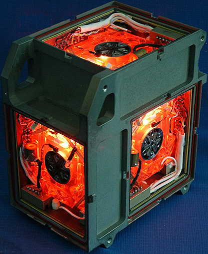
The main difference in the IRS system is that instead of mechanical gyroscopes, ring laser gyro systems are used where there is no moving mass. Instead, laser lights go around circular paths to sense the acceleration in different planes. An exception in terminology is that on the Boeing 777/787, the IRS is called the ADIRU system – standing for Attitude Direction Inertial Reference Unit.
The IRS system can take from 5-20 minutes to align depending on the aircraft’s co-ordinates. The flight crew can monitor the alignment time via the EICAS (Boeing) or Upper ECAM (Airbus). During the alignment, the IRS systems are determining the earth’s rotation relative to the aircraft in a stationary position. It is important that the aircraft remains stationary during the alignment process as any movement will require the alignment cycle to be repeated. As it senses the rotation of the earth, it gains two important pieces of information. It knows the earth is rotating east so then it knows where true north is. It also senses the speed of the earth’s rotation, so it knows the latitude of the plane’s location. The further from the equator, the longer the alignment time will be. This is due to the difference in the earth’s rotation at different locations around the globe. The earth’s rotation is faster the closer the equator is and therefore alignment time will be shorter. The only thing that it then needs is TIME! Longitude has always been a problem in navigation.
The True Story of a Lone Genius Who Solved the Greatest Scientific Problem of His Time is a best-selling book by Dava Sobel about John Harrison, an 18th-century clockmaker who created the first clock sufficiently accurate to be used to determine longitude at sea—an important development in navigation. Great book and a fun read.
Want more on how the ring laser gyro works? Follow the link below...
https://en.wikipedia.org/wiki/Ring_laser_gyroscope