Post by Tim Capps on Aug 26th, 2010 at 8:37pm
The tutorial still is not working for me. ĀNo course shows up on the map, and the route is not followed. ĀThis is what I did. ĀTell me where I'm going wrong:
| CAPTAIN SIM FORUM | |
|
707 Captain >> 707 Captain >> Doppler Navigation
https://www.captainsim.org/forum/csf.pl?num=1282234523 Message started by Tim Capps on Aug 19th, 2010 at 4:15pm |
|
|
Title: Doppler Navigation Post by Tim Capps on Aug 19th, 2010 at 4:15pm
Anyone used the Doppler navigation yet? ĀI'd be interested in a brief description.
EDIT: I was messing around with it over lunch, and apparently it just loads the flight plan and follows it, pretty easy. I don't know if you can manually hopscotch legs between A and B or not, yet. |
|
Title: Re: Doppler Navigation Post by Markoz on Aug 19th, 2010 at 11:02pm
About the only thing I have done with the Doppler Navigation, so far, is turn it on. I did load the 707dpl.PLN with Flight Sim Flight Planner last night and then fly it, but it just shows up as a direct GPS flight from KSEA to KSFF. ;D
Mark Edit (20.08.2010 at 11:29:00): Tim. I read the info on the Doppler in the manual and other than turning it on, NOTHING. Can you give me a small tutorial on what you did? Please? I would love to see how this works. Thanks. |
|
Title: Re: Doppler Navigation Post by Tim Capps on Aug 20th, 2010 at 1:37am
I just used it on the 707 demo flight. I turned it on on the overhead, switched the dial on the console to auto and loaded my flight plan. That gave me distance, but I had to dial in the course myself (glad I had something to do). It followed the flight plan perfectly, with the distance rolling down as we went. Beyond that, I don't know. . I did try a multi-legged trip before and it followed the legs nicely, but all on the A side. I am thinking there is supposed to be some switching, but I haven't experimented enough yet.
|
|
Title: Re: Doppler Navigation Post by Markoz on Aug 20th, 2010 at 7:37am Tim Capps wrote on Aug 20th, 2010 at 1:37am:
Hi Tim. By "707 demo flight", do you mean 707-300 Cold-n-Dark (KSEA) or 707-300 Cleared for takeoff (KSEA)? I just need to be sure we are on the same playing field here. ;) Mark |
|
Title: Re: Doppler Navigation Post by Tim Capps on Aug 20th, 2010 at 11:21am
Cleared for takeoff KSEA.
One thing I could not get it to do was to act on manual inputs, like 30 miles 180, then 30 miles 270. So far I've only been successful with a flight plan. |
|
Title: Re: Doppler Navigation Post by Markoz on Aug 20th, 2010 at 11:48am
You are doing better than me. I can't even get the Doppler to see a flight plan. :'(
I'm going to be a real PAIN and ask for exactly what you did. I'm definitely doing something wrong or missing something completely. Also. Was the plan it did do the 707dpl.pln (KSEA-KSFF)? Thanks in advance. Mark <- is really sruck on this one! :o |
|
Title: Re: Doppler Navigation Post by Tim Capps on Aug 20th, 2010 at 12:09pm
Let's see if I remember lol
Okay, right now I am flying a New York to London route. ĀI started out with the cleared for takeoff situation, then moved it to the active runway at KJFK. Ā(I have things to do today!) ĀI turned on my doppler on the overhead and switched it to "land" from "sea." Ā(Probably doesn't make any difference.) ĀI put the selector on the controls on the center console to "auto" and loaded a flight plan via FSX. ĀI know it worked because the "miles to go" equals the distance to the first waypoint. ĀI manually set the course in "selected course" window, but that doesn't seem to matter, either, because while the miles to go updates at a new waypoint, the selected course window contents never change. I would try reloading the flight plan if that doesn't work. ĀHope this helps. ĀRight now I'm trucking along beautifully and right on the flight plan. |
|
Title: Re: Doppler Navigation Post by Markoz on Aug 20th, 2010 at 1:14pm
Thanks very much for that Tim.
From what you have said, the main difference seems to be a case of "Load the flight plan AFTER turning the Doppler Nav ON". I'm off to give it a try. I'll report back with the results. Thanks again. Mark |
|
Title: Re: Doppler Navigation Post by asanal on Aug 21st, 2010 at 4:51am
Mark,
Tim on the target. I just completed KALB-KPIT flight. Flight Plan working perfect. One other advantages, if you open the Flight Map you can see every time you crossed each legs Map extends blue line highlights flight plan route. IT is amazing. even course and mileage you don't do anything. It will take you to destination. Sanal :D :D |
|
Title: Re: Doppler Navigation Post by Markoz on Aug 21st, 2010 at 5:11am
Hi Sanal.
Thanks for that. I can see I really need to study the manual. I am a complete dummy with this. It's all new to me. :D Mark |
|
Title: Re: Doppler Navigation Post by asanal on Aug 22nd, 2010 at 7:25pm
I cannot believe how 1960 Doppler Navigation like GPS can accept 2010 entire flight plan. But it is real. Put the Flight plan as described above. It doesn't matter how many legs. It will take you to destination. I am wondering, what are for millage inputs. Specially you don not need to touch to the second part.
|
|
Title: Re: Doppler Navigation Post by trisager on Aug 22nd, 2010 at 8:02pm asanal wrote on Aug 22nd, 2010 at 7:25pm:
I don't believe the original equipment had that capability. My understanding is that you could set heading to fly and number of track miles on the next leg of the flight plan on one unit while the other was following the current leg. Switchover would occur either automatically or manually, depending on configurations, and you would then program the next leg, and so on. |
|
Title: Re: Doppler Navigation Post by asanal on Aug 22nd, 2010 at 8:20pm
You are correct.
Thanks |
|
Title: Re: Doppler Navigation Post by Barb. on Aug 23rd, 2010 at 3:39pm
Heya all
After reading some of the comments here I decided to run a little experiment : Load a flight plan from Boston Logan to Atlanta Hartsfield, take off, and turn on doppler nav right after retracting flaps to see what would happen. Here's what my little tests taught me about doppler nav : In order for it to work, you'll need to : - Turn doppler on from the O/H panel - Select 'MAN' mode on the Doppler control panel on the central stand - THEN load the FS flight plan - Turn AP on on 'NAV' mode Then the doppler will follow the flight plan and automatically switch waypoints, using whatever channel (A or B) was selected when you loaded the flight plan. The 'selected course' box will then remain blank or not change (default 000 or whatever you entered) and only 'miles to go' will begin to count down. Rather than turn to the heading corresponding to the active waypoint on the flightplan, stabilise its turn and fly straight forward, as it would happen with the HDG selector, the plane will stick to the flightplan exactly as it is displayed on the world map. This means if the plane turns too slow and overshoots the active leg, it will not just fly parallel to it on the same heading (again, like it would happen with HDG mode), but it will apply corrections and automatically fall back on the planned course. But you can also select 'virtual' waypoint manually as you go, as in 'fly this vector for this long'. In order to do this, you need to select your choosen course and the length of the leg on the dopller control panel on the central stand. If you were following the flightplan on the A channel, use the B channel, and then switch. When you do this, the new selected leg will override the flightplan on the world map screen now only showing the new leg you just entered (heading and length) In this case too, the doppler will make automatic corrections and fall back on the active leg if it overshoots it. Switching between channels A and B works just like switching between NAV radios, allowing you to fly to one waypoint while the next one is already set up and ready to be activated. 10 Nm before a waypoint is reached, a red warning light will show on the panel, indicating it's time to switch waypoints. No need to touch anything if you are still flying the FS flightplan, but if you are entering waypoint manually, this is when you need to switch the current active channel on the doppler panel. At standard AP bank angle, this should allow a nice turn between legs without overshooting. If no next waypoint is entered, the plane will just fly around in circles once 'miles to go' has counted down to 0. I'm not too sure wether this accurately represents the way doppler nav systems are supposed to work, but it can certainly come in handy in some situations. I was expecting the system to be dumb and just blindly follow the data entered, meaning if I turned doppler nav on at a different starting point than specified in the flightplan, it would just follow an offset route. Well, it does not. I like to think this was intended to simplify navigation and simulate other crewmembers making adjustments to decrease the pilot's (your) workload during some phases of the flight. After all the 707 is supposed to be flown by a 3 members crew... ;) Hope this helps. Cheers Nico |
|
Title: Re: Doppler Navigation Post by Tim Capps on Aug 23rd, 2010 at 5:07pm Barb. wrote on Aug 23rd, 2010 at 3:39pm:
When I try to switch from the FSX flight plan to one set up on the B channel, it simply resets the values in the windows and the plane goes in circles. For example, if I'm flying 202 on A with 20 miles to go and set up 180 on B for 20 miles, when I switch the knob from A to B, my B values are reset to 000. Must you wait until the flight plan gets the next waypoint for it to change to a different route? |
|
Title: Re: Doppler Navigation Post by asanal on Aug 23rd, 2010 at 7:56pm
Tim,
Here is, how I program the DN and I do not need to switch A to B . DN will make the switch according FS Flight plan and will take me to destination. 1-Turn "ON" DN at O/H panel 2-Turn DN "Auto" mode on the Central stand 3-Load the FS Flight PLan 4-First Leg mileage will appear in "A" DN unit 5-After Takeoff turn toward first leg course intercept 6-A/P engage / NAV mode "ON" Airplane will intercept to course. Watch the DN Needle. That is all I do.DN will followup FS Plan until to final destination . :D Sanal |
|
Title: Re: Doppler Navigation Post by Jack Vogel on Aug 23rd, 2010 at 9:08pm
When I'm connected to our ACARS server you can see that
its just using GPS, ok so it gives a retro illusion and you have no map :), it still feels a bit inauthentic if you know what I mean. Now I'm curious how they really did their navigation back in the 70s say. Anyone test the INS setup yet? I have been meaning to but got distracted this weekend. |
|
Title: Re: Doppler Navigation Post by TheFinn on Aug 24th, 2010 at 10:55am
Does the Doppler-Navigation System also work without a loaded FS-flightplan?
Tried it yesterday, but it went horribly wrong... :-[ |
|
Title: Re: Doppler Navigation Post by Tim Capps on Aug 24th, 2010 at 11:38am
I have not been able to get the DNS to work without a flight plan. I have not been able to get it to deviate from the flight plan. I *have* been able to get it to follow an entire transatlantic flight plan with no problem.
I figured the GPS was behind the DNS. Doesn't bother me... in fact it gives me a feeling of security :-) |
|
Title: Re: Doppler Navigation Post by Captain Sim 2 on Aug 25th, 2010 at 7:55am
There is an issue with doppler, fix is already available. Please check-in to Your Profile, click Product name link and use Customer Support > Search KB > KB# 5953. We are sorry for inconvenience.
Currently we are working on Doppler tutorial, please stand by. |
|
Title: Re: Doppler Navigation Post by Trailboss on Aug 26th, 2010 at 3:30pm
Question for Tim Capps:
How did you prepare a transatlantic flight plan? Ā When I tried with other CS aircraft, JFK to Lisbon for example, FS wanted to route me way back west and then north and finally east, something like a 20 hour flight plan. ĀThe only way I could get other aircraft to follow a transatlantic plan was to enter it as a GPS Ādirect route with only a beginning and end point, and then add by drag and drop in the map about 2 additional waypoints at each end of the route. ĀEven then sometimes the 757 and 767 went off track. ĀI haven't tried this with the 707 DNS as yet. Is there a better way? I haven't made the DNS modification Capatin Sim recommended in the KB; Ādoes that matter? |
|
Title: Re: Doppler Navigation Post by Tim Capps on Aug 26th, 2010 at 5:12pm
It is a known bug that FSX will route you from New York to London via the scenic western Canadian detour. Co Pilot from Abacus will create a correct route, and so will FS Build. But for default FSX planning, I use your method of creating a GPS route, then dragging the line to the waypoints. It is tedious, but can result in a more realistic flight plan. I put in a lot more than a couple, though.
|
|
Title: Re: Doppler Navigation Post by Captain Sim 2 on Aug 26th, 2010 at 6:10pm
The DOPPLER SYSTEM Quick Start tutorial is now available. Please check-in to Your Profile, click Product name link and use Customer Support > Search KB > KB# 5968.
|
|
Title: Re: Doppler Navigation Post by pavel on Aug 26th, 2010 at 7:08pm
Thanks a lot, sir.
pavel |
|
Title: Re: Doppler Navigation Post by Jack Vogel on Aug 26th, 2010 at 7:51pm
Awesome, thank you CS, I'll have to check it out this evening!!
|
|
Title: Re: Doppler Navigation Post by Jack Vogel on Aug 26th, 2010 at 7:55pm Tim Capps wrote on Aug 26th, 2010 at 5:12pm:
When doing a transcontinental flight i usually will look at Vataware, you can look for flights that have been flown there and it give you a route. There is also 'vroute'. Once I have a route string, I'll use FSBuild to actually generate the flight plan. Still requires manual inspection for any errors but I'm fairly happy with the results. |
|
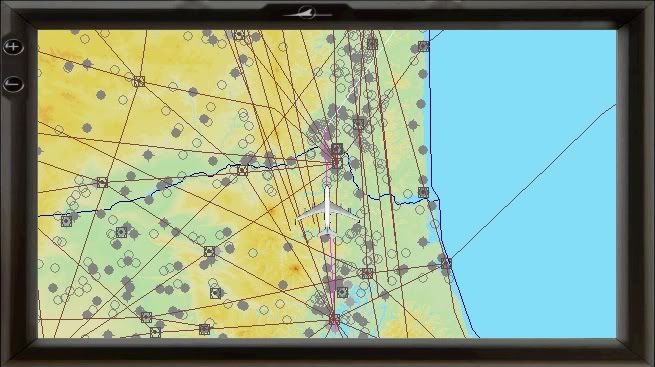
Title: Re: Doppler Navigation Post by Tim Capps on Aug 26th, 2010 at 8:37pm
The tutorial still is not working for me. ĀNo course shows up on the map, and the route is not followed. ĀThis is what I did. ĀTell me where I'm going wrong:
|
|
Title: Re: Doppler Navigation Post by asanal on Aug 27th, 2010 at 1:56am
Tim,
Did you load Flight Plan first and turn DN "On" and Main/Auto second? You have to turn DN "ON" and Main/Auto first, then you should load the Fs Flight Plan second. That is how I am doing and working perfect Sanal |
|
Title: Re: Doppler Navigation Post by Tim Capps on Aug 27th, 2010 at 1:58am
I can get it to work with a flight plan. I thought the tutorial was for using it without a loaded flight plan, but using the controls.
|
|
Title: Re: Doppler Navigation Post by asanal on Aug 27th, 2010 at 2:20am
You have to load flight plan or it will not work. DN doesn't create a flight plan .
|
|
Title: Re: Doppler Navigation Post by Nyxx on Aug 27th, 2010 at 9:06am
A little confused here, Not tyred this yet but here goes....
OK I have a flight plan build in fsx it has e.g 6 legs. I print it out so i know the HDG's and the miles to each leg I do the Doppler set up for the first two legs as I sit at the ramp, When I am on route to the second leg (B) how do I then enter the 3rd leg? etc? ATM i just use VOR-VOR when flying the 707 useing the Doppler means you can use normal airways etc yes? |
|
Title: Re: Doppler Navigation Post by Tim Capps on Aug 27th, 2010 at 11:31am Nyxx wrote on Aug 27th, 2010 at 9:06am:
In theory, you would have leg one on A, leg two on B. Then while you're on B, you would enter leg three on A. And yes, you can use airways and intersections because doppler navigation is completely independent of radio aids. You can also just load the flight plan and have the airplane follow it without further messing with the doppler navigation system, which is the only way I can get it to work so far. |
|
Title: Re: Doppler Navigation Post by Tim Capps on Aug 27th, 2010 at 11:40am asanal wrote on Aug 27th, 2010 at 2:20am:
Hmmm. The tutorial doesn't mention a flight plan. It seems to me that it should be working by inputs into the DNS, as well as by loading a flight plan as a kind of "cheat." All the steps in the tutorial are completely unnecessary if you're going to load a flight plan and have it followed automatically. |
|
Title: Re: Doppler Navigation Post by Captain Sim 2 on Aug 27th, 2010 at 1:24pm
Tim and all, please make sure you have applied the fix in the KB#5953.
|
|
Title: Re: Doppler Navigation Post by Tim Capps on Aug 27th, 2010 at 10:09pm Captain Sim 2 wrote on Aug 27th, 2010 at 1:24pm:
I did, and set the controls on the DNS. ĀI was able to see the route on the map like I'm supposed to. ĀA is my active route in red, and B is in white. But when I turn it to man or auto, the "miles to go" value changes and I no longer have a route on the map. ĀSo it is starting out fine, but then something is interfering and preventing me from using it manually. |
|
Title: Re: Doppler Navigation Post by JayG on Aug 28th, 2010 at 1:02am
[/quote]
I did, and set the controls on the DNS. ĀI was able to see the route on the map like I'm supposed to. ĀA is my active route in red, and B is in white. ĀBut when I turn it to man or auto, the "miles to go" value changes and I no longer have a route on the map. ĀSo it is starting out fine, but then something is interfering and preventing me from using it manually. [/quote] I experimented today with this. Everytime I switched from A to B it dumped the flight plan. I reloaded the FP and just let it follow it without any further switching, it worked as it should. |
|
Title: Re: Doppler Navigation Post by asanal on Aug 28th, 2010 at 2:15am
5953 completed. No flight plan . Only A+B mileage and courses selected.
On Map A course blue line appeared when arrived at B mileage numbers disappeared plane started to circling. :-? :-? |
|
Title: Re: Doppler Navigation Post by asanal on Aug 28th, 2010 at 6:50am Att: Captain Sim, I spent couple of hours to identify the problem with K#5953. Finally I found it. Every time I rename the 5953 "dpl.pln", it is transferring a flight plan to FS as: KSEA (34R) to KSFF. Therefore DNS doest work. Captain Sim will you please check the contains of "dpl.pln" file. I also tried as 707dpl.pln, same results. Sanal |
|
Title: Re: Doppler Navigation Post by Markoz on Aug 28th, 2010 at 12:04pm
Hi Sanal
You are right. The contents of the dpl.pln are as follows: <?xml version="1.0" encoding="UTF-8"?> <SimBase.Document Type="AceXML" version="1,0"> Ā Ā<Descr>AceXML Document</Descr> Ā Ā<FlightPlan.FlightPlan> Ā Ā Ā Ā<Title>KSEA to KSFF</Title> Ā Ā Ā Ā<FPType>VFR</FPType> Ā Ā Ā Ā<CruisingAlt>13500</CruisingAlt> Ā Ā Ā Ā<DepartureID>KSEA</DepartureID> Ā Ā Ā Ā<DepartureLLA>N47░ 25' 53.58",W122░ 18' 28.83",+000433.00</DepartureLLA> Ā Ā Ā Ā<DestinationID>KSFF</DestinationID> Ā Ā Ā Ā<DestinationLLA>N47░ 40' 45.56",W117░ 19' 52.10",+001953.00</DestinationLLA> Ā Ā Ā Ā<Descr>KSEA, KSFF</Descr> Ā Ā Ā Ā<DeparturePosition>34R</DeparturePosition> Ā Ā Ā Ā<DepartureName>Seattle-Tacoma Intl</DepartureName> Ā Ā Ā Ā<DestinationName>Felts</DestinationName> Ā Ā Ā Ā<AppVersion> Ā Ā Ā Ā Ā Ā<AppVersionMajor>10</AppVersionMajor> Ā Ā Ā Ā Ā Ā<AppVersionBuild>61637</AppVersionBuild> Ā Ā Ā Ā</AppVersion> Ā Ā Ā Ā<ATCWaypoint id="KSEA"> Ā Ā Ā Ā Ā Ā<ATCWaypointType>Airport</ATCWaypointType> Ā Ā Ā Ā Ā Ā<WorldPosition>N47░ 25' 53.58",W122░ 18' 28.83",+000433.00</WorldPosition> Ā Ā Ā Ā Ā Ā<ICAO> Ā Ā Ā Ā Ā Ā Ā Ā<ICAOIdent>KSEA</ICAOIdent> Ā Ā Ā Ā Ā Ā</ICAO> Ā Ā Ā Ā</ATCWaypoint> Ā Ā Ā Ā<ATCWaypoint id="KSFF"> Ā Ā Ā Ā Ā Ā<ATCWaypointType>Airport</ATCWaypointType> Ā Ā Ā Ā Ā Ā<WorldPosition>N47░ 40' 45.56",W117░ 19' 52.10",+001953.00</WorldPosition> Ā Ā Ā Ā Ā Ā<ICAO> Ā Ā Ā Ā Ā Ā Ā Ā<ICAOIdent>KSFF</ICAOIdent> Ā Ā Ā Ā Ā Ā</ICAO> Ā Ā Ā Ā</ATCWaypoint> Ā Ā</FlightPlan.FlightPlan> </SimBase.Document> It appears to be a direct GPS flight plan from KSEA to KSFF without waypoints in between. Mark |
|
Title: Re: Doppler Navigation Post by Tim Capps on Aug 28th, 2010 at 1:34pm
I tried a New York to LA flight pland just loaded automatically, and it turned my multi-legged plan into a single leg (which then extended to Hawaii!).
EDIT: This time automatic flight is behaving properly. (Still no joy with manual, though). |
|
Title: Re: Doppler Navigation Post by Markoz on Aug 28th, 2010 at 5:09pm
The fix was only to rename the incorrectly named 707dpl.pln, to dpl.pln, that was placed in Users\USERNAME\Documents\Flight Simulator X files\ when the 707 was installed. Maybe they don't realize there is a mistake/error within it.
Mark |
|
Title: Re: Doppler Navigation Post by asanal on Aug 28th, 2010 at 6:41pm
I re-change the name, but problem continued. I found "dpl.pln went to FS flight plan list. You have to delete from there also.
I am glad we are all very interested in Cs707 and other Cs products. Therefore we are watching closely to identify the problems and bring to CS attention. When all problems are eliminated 707 will fly high. DTS was the navigation backbone in late 1960. It is good we can turn time back and feel those days and how sophisticated airplanes crossed the oceans. :D :D |
|
Title: Re: Doppler Navigation Post by TheFinn on Aug 30th, 2010 at 6:06am
Has anyone already created a ticket for this problem??? Because if we dont, the problem wont be fixed with the next update! :o
Ive tried the mentioned fix in K#5953, but manual (without loading an FS-flightplan) inpunts didnt work after Ive turned the system on. In STBY I had the red line on the map as it should be. But after Ive turned the system to AUTO the mileage changed to "000" and the plane started to turn... |
|
Title: Re: Doppler Navigation Post by Tim Capps on Aug 30th, 2010 at 11:41am
I created a ticket. Passed along to our developers for further consideration. I bet they get this fixed.
|
|
Title: Re: Doppler Navigation Post by TheFinn on Aug 30th, 2010 at 7:59pm
Ok, thanks! Ā;) I hope they do, but if we get a working INS in the VC we get a very good alternative solution... Ā:)
|
|
Title: Re: Doppler Navigation Post by Markoz on Aug 31st, 2010 at 7:58am TheFinn wrote on Aug 30th, 2010 at 7:59pm:
Didn't Captain Sim say they were going to do that as a bonus for us in this Topic? Or did I misread his post? Mark |
|
Title: Re: Doppler Navigation Post by TheFinn on Aug 31st, 2010 at 8:23am Markoz wrote on Aug 31st, 2010 at 7:58am:
Yes they did, and thats how I meant it... ::) We WILL get INS in VC. Should have written it a bit different though. Actually cant wait for this to happen. :D |
|
Title: Re: Doppler Navigation Post by Markoz on Aug 31st, 2010 at 8:29am TheFinn wrote on Aug 31st, 2010 at 8:23am:
No worries. I just read it how it was written. ;) |
|
Title: Re: Doppler Navigation Post by TheFinn on Sep 1st, 2010 at 6:47pm
Finally got the doppler to work without loading a flightplan. The 707 follows the first leg programmed to "A" perfectly. But the second leg programmed to "B" always calculates a wrong course on the map, e.g. when I tune in course 330 in "B", the plane will turn to HDG050... Ā:-?
|
|
Title: Re: Doppler Navigation Post by Markoz on Sep 2nd, 2010 at 2:00pm
I can always get it to follow A, like you, but it always seems to point B at about 180o from what I have it set at. Because of this, I have never entered more than two sections of a flight plan. It just so much easier to create an FS Flight Plan for it to follow.
Mark |
|
Title: Re: Doppler Navigation Post by Barb. on Sep 4th, 2010 at 8:31am TheFinn wrote on Sep 1st, 2010 at 6:47pm:
That is because it would seem the Doppler calculates both legs with the same point of origin, i.e your position when you activate the doppler. I beleive that is also why people got the 'miles to go' reading resetting down to 0 if their miles settings for leg A was longer than leg B. When setting up leg B, the miles to go should be leg A + leg B. A : 50Nm 180 and B : 50Nm 90 will not create a L shaped flightplan but a V shaped one. Cheers Nico |
|
Title: Re: Doppler Navigation Post by Captain Sim on Sep 6th, 2010 at 11:00pm
The dpl.pln file is just an internal service file requred for DNS operations in FSX environment.
It's time to clear the DNS concept. The DNS has been developed as authentic as possible, therefore: - It is not designed to load any flight plans. - Using of the DNS control panel is the only way to create valid DNS route. - Please note DNS route limits are the following: - AUTO mode - 2 segments (legs) - MAN mode - 1 segment leg Ā We are sorry for the cofussion, the info has been missed from the manuals (to be added in 1.1). |
|
Title: Re: Doppler Navigation Post by Tim Capps on Sep 7th, 2010 at 1:38am
The fact remains that when I set up the routes, the first time I switch to either A or B the distance resets to 13 miles and I never do get any route on the map. This is before I even take off. I have applied the fix. It didn't help. As far as I can tell, DNS is broken. But whether you designed it that way or not, it does a dandy job of importing a whole flight plan lol
|
|
Title: Re: Doppler Navigation Post by Markoz on Sep 7th, 2010 at 3:45am Captain Sim wrote on Sep 6th, 2010 at 11:00pm:
Hi Tim. I just tried it the way described in the DNS instructions according to the CS KB#5968 and the above quote by Captain Sim and it's working. I can see the two legs of my flight plan! And it is following the plan too. Ā;D Mark EDIT: The link was showing the wrong image. So I update this post on [timestamp=1283921165]. Sorry. :( |
|
Title: Re: Doppler Navigation Post by TheFinn on Sep 7th, 2010 at 5:48am
Yes it is working, except the course of the second leg is totally wrong (see my post)! For example:
1st leg programmed to "A": Course: 300 Distance 20 miles 2nd leg programmed to "B": Course: 330 Distance: 20 miles The first leg works fine (in AUTO mode), and it switches to the 2nd leg automatically. BUT, now instead to turn to the programmed course of 330, the plane turns to a HDG of 050. :-? Even the leg on the map shows the wrong direction.... Thats some sort of wierd! |
|
Title: Re: Doppler Navigation Post by Tim Capps on Sep 7th, 2010 at 11:37am
So when you guys set up and switch to A for your first leg, it doesn't reset the miles? ĀI can't imagine what I'm doing wrong -- after all, the instructions are pretty simple. ĀMaybe you could provide a step by step?
EDIT: Never mind. ĀAccording to the tutorial, something is going wrong when I switch to A. ĀInstead of showing the route, the miles just reset and I get nothing. ĀI don't think this is operator error. I'm glad it's working for others, though. |
|
Title: Re: Doppler Navigation Post by Markoz on Sep 7th, 2010 at 12:20pm Tim Capps wrote on Sep 7th, 2010 at 11:37am:
Hi Tim. You MUST turn the Stage Selector to A AFTER you turn the Control Switch to MAN or AUTO. If you turn the Stage Selector to A before you turn the Control Switch to MAN or AUTO, it will reset the miles to 0 (zero). More woes though! :( I just did a flight from YMML (Melbourne) to YSSY (Sydney). I set A to 45o and 372 miles and I set B to 5o 10 miles. This should have given me a flight path to out over the coast off of Sydney then a 30o intercept for ILS 34L. As the flight progressed, the heading slowly move to 38o (instead of 45o) which put me on the coast at Sydney, with an intercept on ILS 34L near impossible. Then, when I got to the start of B anyway, it turned to a heading of 225o with a distance of 372 miles. It was returning me back to Melbourne! On the other test I was doing, from Seattle, I set it all up on the ground just prior to takeoff. As soon as I turned the A/P to NAV, it turned to intercept the course. With my Melbourne to Sydney trip, it refused to set while I was still on the ground. It worked fine once I was airborne. It's sure got me beat. :-/ Mark |
|
Title: Re: Doppler Navigation Post by Tim Capps on Sep 7th, 2010 at 1:15pm Quote:
Doesn't make any difference for me. ĀI put it on standby or off and the selector switch in neutral to set up my legs. ĀThen I turn it to auto. ĀThen I turn the selector switch to A. ĀIt resets miles to some number; last time it was 23 instead of 13. ĀI never see the red line on the Shift+4 map. ĀI am not loading a flight plan if that makes any difference and this is on the ground during preflight. ĀI just tried it again. ĀNo joy. If some of the most knowledgable and dedicated (or at least diligent) people are having problems I don't think clearer instructions are going to help. ĀThere are only so many ways you can do these steps and I've tried them all, I think, to no avail. EDIT: It does seem to make a difference whether you are on the ground or in the air. In the air I was at least able to get the red line and have it intercept. But no luck switching back and forth in manual mode. And the miles are still resetting and the line disappearing whenever I make a change. I still say it isn't working right. |
|
Title: Re: Doppler Navigation Post by Markoz on Sep 7th, 2010 at 1:32pm
Hi Tim.
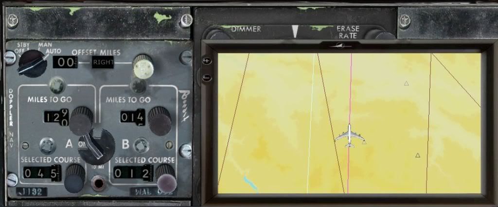
I'm doing another flight at the same time as I'm writing this. YMML to YSSY again (because it's only 1 - 1.2 hours). I couldn't get it to accept the plan until airborne again! I am getting A to work (364 miles 45o). B probably wont (12 miles at 12o). I'll know in an hour. 130 miles down the track and my heading is now 43o which looks like it wont get me far enough off the coast to enable a good ILS intercept. After this. I'm going to try from the 707-300 Cleared for takeoff (KSEA) flight, and see if I can start it whilst on the ground, again, like the first time. Mark EDIT-[timestamp=1283868555]: I have just finished the flight. Have a look at the image. If you look closely at it, the B route line (white) is running back in the opposite direction to the A route line. Look at what I have entered for B though! After reaching the end of A, B changed to 360 miles to the south instead of 12 miles north. |
|
Title: Re: Doppler Navigation Post by JayG on Sep 7th, 2010 at 5:28pm
Why make this so complicated? I just make sure the Doppler is ON, load a flight plan, take off, engage the AP and set it to NAV, done deal!
|
|
Title: Re: Doppler Navigation Post by Barb. on Sep 7th, 2010 at 5:29pm
Again, I believe this happens because stage A and B use the same point of origin, which is your position when you turn the Doppler to MAN/AUTO. If A is set to 45░, 275 miles, and B to 5░, 10 miles, the plane will NOT turn to 005 for 10 miles when reaching B, it will turn back towards a point that is 10 miles bearing 5░ from where you were when you turned the DNS on, hence the big U-turn you experienced.
Just try this : If you want to fly leg A 100 miles 180░, then leg B 100 miles 90░ in an L pattern, DNS input should be A : 180░ 100 miles, B : 135░ 140 miles. If you set up leg A 180░ 100 miles and leg B 90░ 140 miles on the DNS, upon reaching B, you'll find yourself turning back heading 50░ something degrees to a point 140 miles East of your initial position. Legs A and B are calculated from the same point of origin. They are shown on the map as forming one trajectory, but what appears on the map is NOT what the DNS calculates. That's the only plausible explanation I've found. Pythagorus is my copilot :D I'm only using DNS for long cross-oceans or cross-desert legs, the rest of the time I still stick to VOR to VOR. Sure, I'm not flying the airways, but at least I get to my destination every time. Cheers Nico |
|
Title: Re: Doppler Navigation Post by Markoz on Sep 8th, 2010 at 4:52am JayG wrote on Sep 7th, 2010 at 5:28pm:
The quick answer is: Because I really want to fly a Doppler Navigation flight that I entered the details myself. I know we can do a FS Flight Planner flight but it just isn't the same. And I'm not implying that there is anything wrong with doing it that way either. ;) Mark |
|
Title: Re: Doppler Navigation Post by JayG on Sep 8th, 2010 at 3:35pm
Fair enough, I'm more the lazy type Ā;D
|
|
Title: Re: Doppler Navigation Post by Markoz on Sep 8th, 2010 at 3:53pm
Hi Nico.
If you look at the image of the Map I posted here, you will see that the flight plan for Stage A and Stage B are perfect. It work beautifully on that flight. Unfortunately, I have not been able to repeat that flight, nor any other two Stage flight. I can't, for the life of me, figure out what I did right then, that I am doing wrong now. I have tried all sorts of different methods, but to no avail. Stage B always goes wrong and sometimes Stage A changes the distance and heading when I turn it all on. I have submitted a Ticket and it has been passed on to the development team. Mark |
|
Title: Re: Doppler Navigation Post by Captain Sim on Sep 8th, 2010 at 5:04pm JayG wrote on Sep 7th, 2010 at 5:28pm:
It's vintage system designed mid last century :) Real DNS does not load any flight plans. But routes manually entered using its control panel. We are writting more detailed manual on the DNS. Note: DNS works inflight only. There's a bug with system activation once airbone, so in 1.0 please programm DNS inflight only. 2. There's a bug in Stage B calculation. It use initial point (point 1 instead of 2) for point 3 calculation. To be fixed in 1.1 |
|
Title: Re: Doppler Navigation Post by Markoz on Sep 8th, 2010 at 5:54pm
Thanks Captain Sim. I look forward to the fix.
Mark |
|
Title: Re: Doppler Navigation Post by Tim Capps on Sep 8th, 2010 at 6:05pm
I'm really glad it is broken lol. I mean I'm glad I'm just not completely stupid and we can hope to have a better experience with it. Sounds like best to just leave it alone until the fix. I'm looking forward t having something to do on those long hauls.
|
|
Title: Re: Doppler Navigation Post by Barb. on Sep 8th, 2010 at 11:26pm Quote:
At the risk of repeating myself : I knew it :D Quote:
Thanks CS. A working DNS will be a fine addition to a fantastic package. Now I'm even more anxious to get my hands on 1.1 :D Cheers Nico |
|
Title: Re: Doppler Navigation Post by Markoz on Sep 9th, 2010 at 1:15am Quote:
Mark |
|
Title: Re: Doppler Navigation Post by TheFinn on Sep 10th, 2010 at 5:55am
Great news CS! Looking forward to the 1.1 update! :)
|
|
Title: Re: Doppler Navigation Post by LOU on Sep 15th, 2010 at 6:14pm
Just a few thoughts....
Doppler Nav in the 707 was WW-II tech. The 707 was designed with 4 Crew members, one of which was the Navigator. The airlines opted to use this "new" doppler nav to get rid of the navigator. Crossing the north Atlantic back in the late 60's and early 70's was a chore. We had 120 NM separation since doppler was so crude. If we had a smooth sea the doppler would go into coast (DR) for hours. Great system! We backed up the doppler with Loran and Consolan to get a line of position and make a fix, but this was not very accurate for a plane going 600 KTS! Many times we would look for other contrails to see if we were on course. :D Even the early 747's had a sextant port in the roof. Old stuff is hard to get rid of. ;D The flight plan was loaded by hand one leg at a time - best we had at the time. It was like night and day when INS came along and you could load 10 legs at a time. When IRS came along and computers got better is when we were able to load a full flight plan. Today the flight plan can be loaded from the dispatcher via radio or laptop computer. Lou |
|
Title: Re: Doppler Navigation Post by petenoak on Aug 17th, 2015 at 4:11pm
I know this is an old topic, but can anybody confirm what I'm seeing with the CS 707 Doppler System?
If I save a flight and re-load, the Doppler settings for legs A & B are lost. Is there any work-around to avoid this? peter |
|
Title: Re: Doppler Navigation Post by Markoz on Sep 3rd, 2015 at 2:21am petenoak wrote on Aug 17th, 2015 at 4:11pm:
Hi Peter. I don't think you can do a "work-around" for Doppler Navigation (at least not at this time). The Doppler Navigation requires the dpl.pln (KSEA - KSEA) to function correctly, so when the 707 first loads, it also loads that flight. I know it's a pain, but you have no choice but to redo the Doppler Navgation route again on resuming a 707 flight. :( Maybe in a future update, we may get a way of saving the Doppler Navigation in a save flight, so when you resume a flight, it's already there. :) |
|
CAPTAIN SIM FORUM » Powered by YaBB 2.6.0! YaBB Forum Software © 2000-2024. All Rights Reserved. |